BOOMERS OUT THERE THIS EVENING. WE DO INDEED, BECAUSE OF THE WARM, ALMOST SUMMER LIKE TEMPERATURES IN MANY AREAS, WE’VE SEEN TEMPERATURES CLIMB WELL UP INTO THE 80S AND EVEN AT THE HOT SPOT IN DOWNTOWN BALTIMORE NEAR THE INNER HARBOR, TYPICALLY RUNS HOT 91 DEGREES RIGHT NOW AT THE MARYLAND SCIENCE CENTER IN BALTIMORE. IT’S ONLY 82 IN SYKESVILLE, THOUGH, AND 80 UP IN PARKTON. SO TO OUR NORTH AND WEST, IT IS BEGINNING TO COOL OFF A BIT. BUT AROUND BALTIMORE AND POINTS SOUTH, IT HAS BEEN AN UNSEASONABLY WARM MID-APRIL DAY, NO DOUBT ABOUT IT. AND THAT HAS SET THE STAGE FOR POSSIBLE THUNDERSTORM ACTIVITY. ALL THE PINK SHADED COUNTIES HIGHLIGHTED HERE ARE UNDER A SEVERE THUNDERSTORM WATCH. IT MEANS THE CONDITIONS ARE FAVORABLE FOR A STORM THAT COULD HAVE 60 MILE AN HOUR GUSTS AND ONE INCH DIAMETER HAIL ANYWHERE IN THIS AREA INCLUDES BALTIMORE AND HARFORD COUNTIES, AND MUCH OF THE EASTERN SHORE DOWN TO OCEAN CITY. IT GOES UNTIL TEN. I DON’T THINK IT WILL BE IN EFFECT THAT LONG, BECAUSE THESE STORMS ARE GOING TO MOVE THROUGH QUICKLY, BUT FOR THE NEXT COUPLE OF HOURS, THE POTENTIAL IS THERE ABOUT A 20% CHANCE THAT ANY ONE SPOT GETS HIT BY ONE OF THESE STORMS TRACKING THROUGH FOR THE NEXT HOUR OR TWO, AND THEN THE SKIES CLEAR OUT NICELY. AND TOMORROW, WHILE IT WILL BE MILD, IT WON’T BE NEARLY AS WARM AS TODAY. HERE’S WHERE THE HOT SPOTS ARE RIGHT NOW AS FAR AS THUNDERSTORM ACTIVITY. AND NOTICE BALTIMORE IS KIND OF SITTING RIGHT IN BETWEEN ALL OF THE ACTIVITY. WE HAD A WARNING IN CECIL COUNTY JUST A FEW MINUTES AGO THAT HAS EXPIRED NOW, AND THE WARNING IS NOW OVER IN NORTHERN DELAWARE, THIS CELL AGAIN COULD HAVE 60 MILE AN HOUR WIND GUSTS AND THE HAIL IN ONE INCH IN DIAMETER. JUST NORTH OF MIDDLETOWN IN NORTHERN DELAWARE. WE’VE GOT ANOTHER STORM COMING OUT OF SOUTH CENTRAL PENNSYLVANIA, PRETTY MUCH CLOSE TO SHREWSBURY RIGHT NOW. WARNING IN EFFECT HERE UNTIL 5 P.M., BUT AGAIN, IT’S MOVING 40 MILES AN HOUR TO THE SOUTHEAST, SO IT’S LIKELY TO CROSS THE LINE AND MOVE INTO NORTHERN HARFORD COUNTY HERE IN THE NEXT FEW MINUTES WITH SOME HAIL AND GUSTY WINDS SOUTH OF D.C. ALSO, SOME BIG STORMS AND ALL OF THIS MOVING SOUTH AHEAD OF A COOL FRONT, WHICH IS GOING TO MOVE THROUGH HERE IN THE NEXT COUPLE OF HOURS AND END THE THUNDERSTORM THREAT. BUT UNTIL THAT FRONT CAN GET PAST US, WE’VE STILL GOT A POSSIBILITY OF A STRONG STORM OR TWO. TOMORROW WILL BE IN THAT SLIGHTLY COOLER AIR NORTH OF THE FRONT, BUT IT WON’T LAST LONG. ANOTHER STORM EAST OF THE ROCKIES WILL BE COMING. OUR WAY, AND THAT’S GOING TO PUSH THE FRONT BACK IN OUR DIRECTION AS A WARM FRONT LATER THIS WEEK, WHICH WILL BRING MORE UNSETTLED WEATHER. SO I THINK WE’VE GOT SOME STORMS THIS EVENING. THEN IT QUIETS DOWN TOMORROW AND THEN THE SHOWERS COME BACK MIDWEEK. THIS IS FUTURECAST AT 615 AND IT’S HIGHLIGHTING THE MOST UNSTABLE AREA IN THE STATE DOWN IN SOUTHERN MARYLAND. SO ONLY A COUPLE ISOLATED STORMS AROUND HERE FOR THE NEXT HOUR OR TWO. AND THEN WORK OUR WAY TOWARD NINE TONIGHT. AND SKIES ARE BEGINNING TO CLEAR NICELY, WHICH IS GOOD NEWS FOR THE O’S GAME PLAYING THE TWINS AT CAMDEN YARDS TONIGHT. PARTLY CLOUDY SKIES, SIX 3085 DEGREES IN DOWNTOWN BALTIMORE, COOLING INTO THE MID 70S AS THE EVENING WEARS ON. SO IMPACT WEATHER FOR THE NEXT FEW HOURS. A COUPLE SCATTERED STRONG STORMS AND THEN CLEARING OUT AND TEMPERATURES BY TOMORROW MORNING. DROPPING INTO THE 50S. SUNSHINE TOMORROW UP TO 77. SO WARM BUT NOT AS WARM AS TODAY WITH A LIGHT SOUTH TO SOUTHEAST BREEZE. AND AGAIN ENJOY THAT TUESDAY BECAUSE MIDWEEK THE SHOWER CHANCES ARE GOING TO RETURN ON WEDNESDAY WITH A HIGH OF 65. UPPER
Severe Thunderstorm Watch: Storms possible across much of Maryland
![WBAL logo]()
Updated: 10:30 AM EDT Apr 16, 2024
UPDATE 5:30 p.m. -- The severe thunderstorm watch is canceled for Central Maryland and the Upper Eastern Shore, but remains in effect for Southern Maryland's Calvert, Charles and St. Mary's counties, as well as the Lower Eastern Shore.|| Closings/Delays | Weather Advisories | Radar | Forecast | Email Alerts | Send us your pics ||(ORIGINAL STORY): A Severe Thunderstorm Watch is in effect Monday for much of Maryland.Heavy storm activity moved off to the south Monday afternoon. More scattered showers will move in from the north that could intensify.Most of Maryland is at risk of isolated storms, with risk of more severe storms higher in Southern Maryland and on the Eastern Shore.The watch is scheduled to last until 10 p.m. Affected areas include:Anne Arundel CountyBaltimore CityBaltimore CountyCalvert CountyCaroline CountyCharles CountyDorchester CountyHarford CountyHoward CountyKent CountyMontgomery CountyPrince Georges CountyQueen Anne's CountySomerset CountySt. Mary's CountyTalbot CountyWicomico CountyWorcester County | LINK: MDOT SHA's Statewide Transportation Operations Response Map Download the WBAL-TV app NOW and turn on push alerts to be aware of severe weather warnings, listen to NOAA Weather radio, and watch WBAL-TV 11 when impending severe weather develops.@wbaltv11 | @TTasselWBAL | @AvaWBAL | @TonyPannWBAL | @DalenciaWBAL | @ChelseaWeatherWBAL-TV 11 Maryland Weather RadarApp users tap here for interactive radar.Maryland's 7-Day Weather ForecastAlert Days vs. Impact DaysYou may see the WBAL-TV 11 Weather Team highlight Alert Days or Impact Days in the forecasts. Here's what that means:An Impact Day is when weather will likely disrupt your normal daily schedule or routine.An Alert Day is when there's a threat of extreme, severe and possibly life-threatening weather.Potential power outagesStorm conditions could cause outages by knocking down tree limbs onto power lines and other electric delivery equipment. Baltimore Gas and Electric asks all customers to report their outage in any of the following ways: Online, at BGE.comBGE's free mobile app, available at the Apple Store or Google Play Text message, to 69243 Phone, by calling 877-778-2222The latest outage information, including total number and general locations, is available on the BGE.com outage map.As a reminder, fallen overhead power lines should never be approached or touched even if the lines do not appear to be live or sparking. Call BGE at 877-778-2222 to report fallen electrical lines, power outages and gas odors.Share your weather photos and videosShow us your weather photos and videos, we may use them on 11 News or online!DIRECT UPLOAD: Use this form to upload photos or video.EMAIL: Just email your photos and video to news@wbaltv.com.ALERTS: Severe weather alerts from the WBAL-TV app: step-by-step guideCLOSINGS: See if schools, businesses or organizations have closed or delayedRADAR: Track snow, sleet or freezing rain with WBAL-TV's interactive radarROADS: Check for crashes and backups with our interactive traffic mapWINTER: Guide: Snow safety, driving hazards, power outagesTORNADO SURVIVAL: 5 things you need to do nowHURRICANE PREPARATION: How to prepare for hurricane season
BALTIMORE — UPDATE 5:30 p.m. -- The severe thunderstorm watch is canceled for Central Maryland and the Upper Eastern Shore, but remains in effect for Southern Maryland's Calvert, Charles and St. Mary's counties, as well as the Lower Eastern Shore.
|| Closings/Delays | Weather Advisories | Radar | Forecast | Email Alerts | Send us your pics ||
(ORIGINAL STORY): A Severe Thunderstorm Watch is in effect Monday for much of Maryland.
Heavy storm activity moved off to the south Monday afternoon. More scattered showers will move in from the north that could intensify.
Most of Maryland is at risk of isolated storms, with risk of more severe storms higher in Southern Maryland and on the Eastern Shore.
The watch is scheduled to last until 10 p.m. Affected areas include:
- Anne Arundel County
- Baltimore City
- Baltimore County
- Calvert County
- Caroline County
- Charles County
- Dorchester County
- Harford County
- Howard County
- Kent County
- Montgomery County
- Prince Georges County
- Queen Anne's County
- Somerset County
- St. Mary's County
- Talbot County
- Wicomico County
- Worcester County
| LINK: MDOT SHA's Statewide Transportation Operations Response Map
Download the WBAL-TV app NOW and turn on push alerts to be aware of severe weather warnings, listen to NOAA Weather radio, and watch WBAL-TV 11 when impending severe weather develops.
@wbaltv11 | @TTasselWBAL | @AvaWBAL | @TonyPannWBAL | @DalenciaWBAL | @ChelseaWeather
WBAL-TV 11 Maryland Weather Radar
App users tap here for interactive radar.
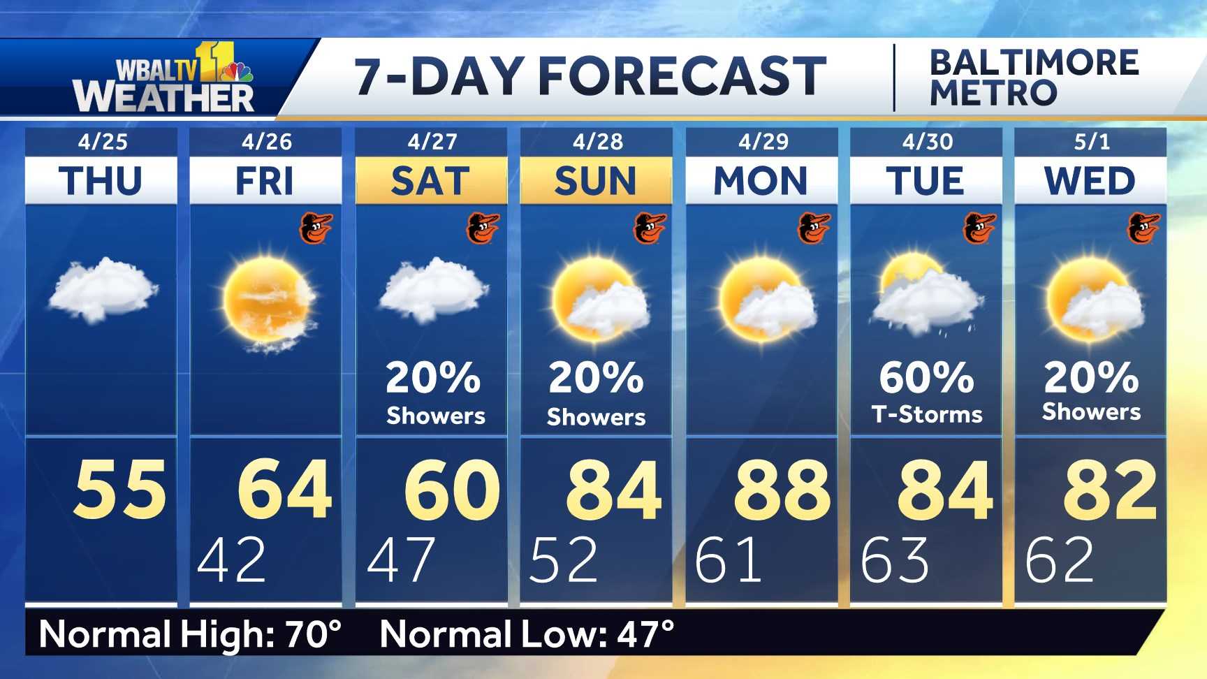
Maryland's 7-Day Weather Forecast
Alert Days vs. Impact Days
You may see the WBAL-TV 11 Weather Team highlight Alert Days or Impact Days in the forecasts. Here's what that means:
- An Impact Day is when weather will likely disrupt your normal daily schedule or routine.
- An Alert Day is when there's a threat of extreme, severe and possibly life-threatening weather.
Potential power outages
Storm conditions could cause outages by knocking down tree limbs onto power lines and other electric delivery equipment. Baltimore Gas and Electric asks all customers to report their outage in any of the following ways:
The latest outage information, including total number and general locations, is available on the BGE.com outage map.
As a reminder, fallen overhead power lines should never be approached or touched even if the lines do not appear to be live or sparking. Call BGE at 877-778-2222 to report fallen electrical lines, power outages and gas odors.
Share your weather photos and videos
Show us your weather photos and videos, we may use them on 11 News or online!