Warm Thursday leads into stormy finish to Friday
CEDAR RAPIDS, Iowa (KCRG) - A risk for severe weather returns to eastern Iowa by Friday.
Sunny, warm, and breezy at times
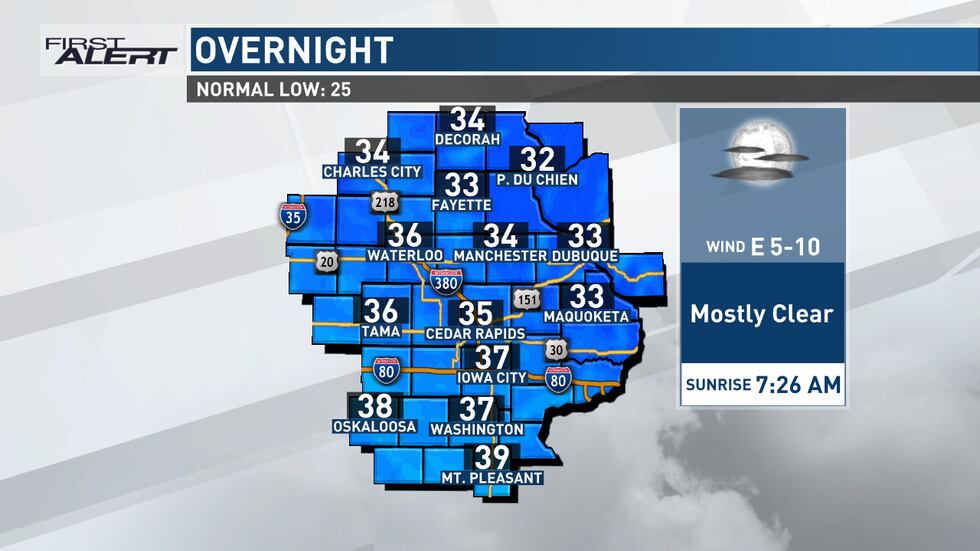
Skies remain mostly clear into tonight, and winds should continue to be fairly light from the east or east-northeast. With a dry air mass still in place, this sets up a good night for temperatures to cool. Expect lows in the 30s.
As the sun comes up on Thursday, a steady warm-up looks likely, too. Dry air also warms up easier, and a subtle shift in our winds to something with a more southerly component will give our temperatures a boost. Highs will be in the upper 60s north to mid 70s south. These readings are roughly 30 degrees above normal for this time of year.
Continued southeasterly winds, and a gradual increase in moisture at the low levels of the atmosphere, will keep us from cooling much on Thursday night. Lows will only drop into the low to mid 40s as a few more clouds arrive.
Your First Alert: First severe storm risk of the season on Friday
As a storm system moves into the central United States, it will gain strength and move closer to the state. Out ahead of it, southerly flow on Friday will give us an additional boost to temperatures. Highs will head for the 70s or even close to 80, potentially setting new records in places.
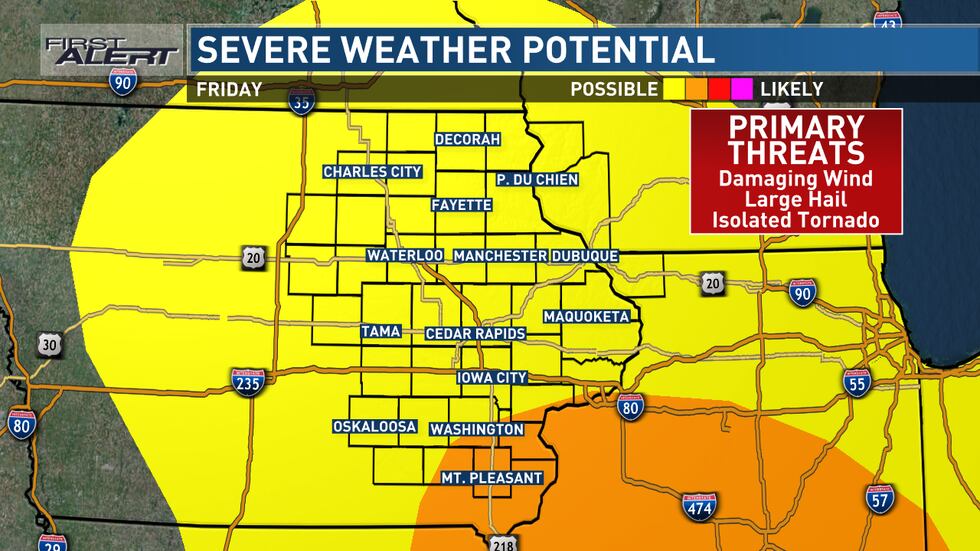
The Storm Prediction Center includes the entire TV9 viewing area in a risk for severe thunderstorms during the afternoon and evening of Friday. The far southeastern counties are included in the higher enhanced risk category.
Much of the day will be spent with gusty breezes (up to 40 to 50 mph at times), but little to no other threatening weather. Instead, we’ll be building up moisture and instability ahead of the low pressure system and its associated frontal boundary. Dew points will increase, though they’ll stay relatively modest in the mid 50s. Even still, when combined with the change of wind speed and direction with height (known as wind shear) and the temperatures across the atmosphere vertically, this will provide sufficient energy for those storms to develop.
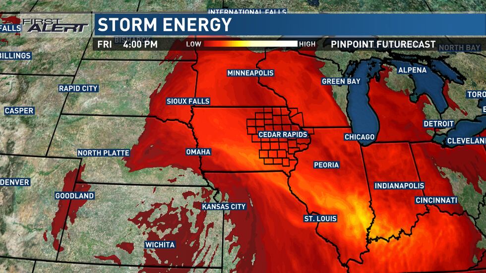
At this point, it looks like storms will develop in a northwest-to-southeast arc from western Iowa into northern Missouri between about 3:00 p.m. to 5:00 p.m. These storms will consolidate into a line or a few lines and race to the northeast at 50 to 60 mph. This takes it into the western and southwestern edges of the viewing area by 5:00 p.m. to 7:00 p.m.
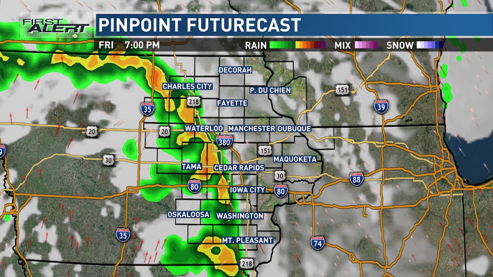
Moving at those fast speeds, these storms would generally reach the northeastern side of the viewing area by 9:00 p.m. to 11:00 p.m., exiting toward Wisconsin and Illinois after that. Behind this initial line, winds will remain gusty, and an isolated shower could still occur in some parts of the area.
Damaging winds are the main threat with storms on Friday evening, but large hail and a few tornadoes could also occur. Some wind gusts could be especially strong, given the intensity of the winds with this storm system higher up in the atmosphere.
What to do if storms threaten your area
With this being the first risk for severe storms this season, it’s a good idea to review the steps to take if a warning is issued. Since storms will be moving quickly, your time to react may be shorter than normal.
If a storm approaches your area, seek shelter indoors. If a warning is issued, get to the lowest floor of your home, away from windows. In the event of a tornado warning, put as many walls between you and the outside as possible, like in an interior closet or bathroom. A basement is best if you have one. Cover your head and neck with pillows or blankets, or a bike helmet if you have one. If you’re in a mobile home, abandon it for more substantial shelter. If caught outdoors, try to get to an indoor shelter. As a last resort, lay flat in a ditch while protecting your head and neck. Don’t seek shelter under bridges or overpasses.
It’s important to make sure to have multiple ways to receive warnings. A NOAA Weather Radio is a great tool in this case. Make sure it’s plugged in and turned on, ready to receive warnings, before you head to bed. We also recommend the KCRG-TV9 First Alert Weather App, which can give you customized alerts for your location. Of course, we’ll also provide updates on KCRG.com and KCRG-TV9 as conditions warrant.
Cooler for the weekend
As this storm system pulls away from the region, we’ll get into the colder side of it. Temperatures will fall into the 40s on Saturday morning, with only a very slight uptick into the upper 40s to around 50 for an early day high. Then, temperatures will fall.
Scattered showers could wrap around this system as blustery northwest winds gust to 40 mph or more. These will be light in nature if they occur. As temperatures drop, some snowflakes could make an appearance, with a snow shower or two possible Saturday night. Accumulations look unlikely with this potential.
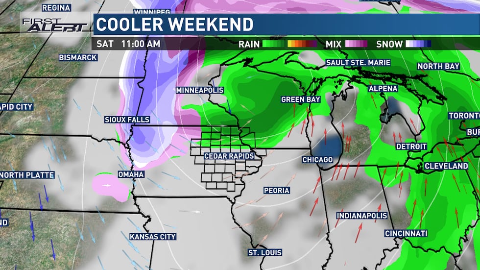
Drier weather is in store for Sunday but we’ll also have the chilliest conditions available on our current 9-day forecast. Lows will be in the 20s with highs in the upper 30s to low 40s. Blustery winds will still be present, so wind chills will be a factor to wrap up the weekend.
A big bounce temperature bounce and a midweek storm
It won’t take long for temperatures to soar again, with lows in the 20s on Monday translating into highs in the 50s to low 60s by the afternoon. For those planning to celebrate St. Patrick’s Day, the weather will be on your side.

Readings well into the 60s are likely again on Tuesday with some wind to go along with it. This takes place ahead of another storm system that brings a chance for rain that could change to snow on Wednesday. This also brings a downturn in temperatures, closer to normal yet again.
Copyright 2025 KCRG. All rights reserved.