

There's a 39 percent chance a catastrophically powerful hurricane will make landfall somewhere on the East Coast this year — and a pretty good chance that prediction isn't right.
In a nutshell, that's the wild science of tropical forecasting in April, so far ahead of the storm season.
The landfall prediction comes from the Tropical Meteorology Project, part of annual forecast series for the June through November hurricane activity period.
The project is a brainchild of the late hurricane guru Bill Gray and is considered a benchmark of hurricane research.
But Phil Klotzbach, the project leader, said the accuracy of the pre-season forecast in the past hasn't been that good.
"The Atlantic Basin has the largest year-to-year variability of any of the global tropical cyclone basins," he said. "Everyone should realize that it is impossible to precisely predict this season's hurricane activity in early April."
Klotzbach said he would generally characterize "the skill of the April forecasts as modest, the skill of the June forecasts as good and the skill of the August forecasts (moving into the peak of the season) as excellent."
"There is just a lot that can change between now and the peak of the season," he added.
Prediction science is still research and a work in progress. Hopefully, the accuracy is improving year to year as more historic data get loaded in. Public curiosity drove the project to publish the predictions and the researchers do it in part to call attention to the threat from the storms, according to the project's website.
Right now, the ability to forecast accurately improves so much from April to June that the National Oceanic and Atmospheric Administration won't publish a forecast until the end of May.
"I think that it is too early to make any confident comment about the upcoming hurricane season," said Gerry Bell, NOAA's lead seasonal forecaster.
Coinciding with the ability to accumulate better data, the climate appears to be turning more volatile — keeping the research in a catch-up mode.
Klotzbach said last fall — in the wake of the devastating 2017 season — that it's too soon for the historic data to pick up trends for the warming climate. But global-scale forecast models already are suggesting small increases in intensity for the strongest storms in the future, he said.
Last year was a case in point. The April predictions for 2017 were similar to this year — suggesting a slightly worse than normal season.
That didn't happen. Extraordinarily powerful storms raked the United States and Caribbean islands, killing hundreds and stranding hundreds of thousands. Nine storms became hurricanes, six of those became major hurricanes.
Four of the worst hurricanes formed one after the other from late August into September. Two storms — Irma and Maria — reached cataclysmic Category 5 with winds stronger than 156 mph.
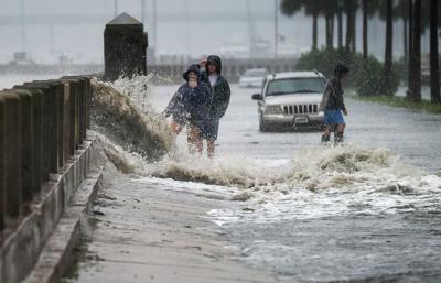
In South Carolina, brushes by then-Tropical Storm Irma and other storms caused millions of dollars in damage.
The project's forecast model, like the others, weaves historic data in with current conditions and weather trends, such as sea surface temperatures that fuel hurricanes and shifting global wind cycles that change those temperatures.
One glitch can throw off the whole works. Last year, forecasters called for warming Pacific waters, El Nino, to stir winds that disrupt hurricanes in the Atlantic. The warming never came.
This year, the Pacific trend and any number of other factors remain what forecasters call neutral, not really suggesting what might happen.
"I'm putting a little less stock in the numerical model predictions for this season, given how poorly they did last year. I did a lot more statistical analysis this year," Klotzbach said.


